The good anchorage at Silver Strand lies in the lee of the peninsula and affords protection in winds from the west through north to east, but is exposed to southerly winds. The access to the anchorage is straightforward in all reasonable conditions and although tidal streams are occasionally strong, Silver Strand is accessible at all states of the tides.

Keyfacts for Silver Strand
Facilities


Nature


Considerations

Protected sectors
Approaches


Shelter


Last modified
July 19th 2018 Summary
A good location with straightforward access.Facilities


Nature


Considerations

Position and approaches
Expand to new tab or fullscreen
Haven position
 55° 12.464' N, 006° 57.622' W
This is the middle of the bay in approximately 3 metres of water.
What are the initial fixes?
The following waypoints will set up a final approach:(i) Lough Foyle South Channel Initial Fix
 55° 11.760' N, 006° 57.084' W
Midway between the shore and the southern edge of the Tuns Bank in the narrowest part of the South Channel in approximately 10 metres of water.
(ii) Lough Foyle North Channel Initial Fix
 55° 14.155' N, 006° 53.700' W
One mile east of Inishowen Head and 400 metres northwest of Red Tuns Light (port hand) Buoy F1. R.3s. It is set on the 222° line of bearing of the Martello tower on Magilligan Point that leads into the North Channel.

What are the key points of the approach?
Offshore details are available in the northeast Ireland’s Coastal Overview for Malin Head to Strangford Lough  .
.
 .
.- Lough Foyle’s approaches, the run up the lough to the River Foyle and beyond are detailed in the Foyle Port Marina (Derry City)
entry.
- Once outside the entrance to Lough Foyle look for the Warren Lighthouse to identify the bight but do not enter its northeast end as it is completely foul.
Not what you need?
Click the 'Next' and 'Previous' buttons to progress through neighbouring havens in a coastal 'clockwise' or 'anti-clockwise' sequence. Below are the ten nearest havens to Silver Strand for your convenience.
Ten nearest havens by straight line charted distance and bearing:
- Cornashamma Bay - 0.5 nautical miles NE
- Greencastle - 0.9 nautical miles WSW
- Magilligan Point - 1.1 nautical miles SSW
- White Bay - 1.7 nautical miles NE
- Portnocker - 1.9 nautical miles NE
- Portkill - 2.2 nautical miles NNE
- Moville - 3.1 nautical miles WSW
- Kinnagoe Bay - 3.5 nautical miles NNW
- Carrickarory Pier - 3.7 nautical miles WSW
- Tremone Bay - 5.4 nautical miles NW
These havens are ordered by straight line charted distance and bearing, and can be reordered by compass direction or coastal sequence:
- Cornashamma Bay - 0.5 miles NE
- Greencastle - 0.9 miles WSW
- Magilligan Point - 1.1 miles SSW
- White Bay - 1.7 miles NE
- Portnocker - 1.9 miles NE
- Portkill - 2.2 miles NNE
- Moville - 3.1 miles WSW
- Kinnagoe Bay - 3.5 miles NNW
- Carrickarory Pier - 3.7 miles WSW
- Tremone Bay - 5.4 miles NW
Chart
How to get in?

Silver Strand is located within a bight on the Inishowen Peninsula situated immediately outside the entrance to Lough Foyle.
 Entered between Magilligan Point and the Inishowen shore, Lough Foyle’s approaches, the run up the lough to the River Foyle and beyond are detailed in the Foyle Port Marina (Derry City)
  entry.
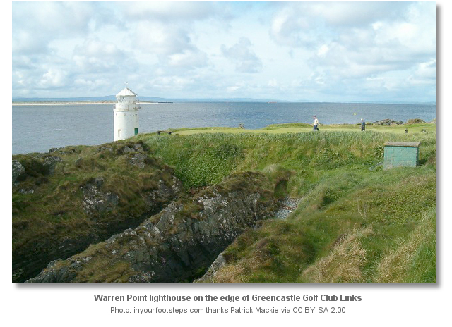
 Once outside the entrance it is simply a matter of finding the Silver Strand Bay bight that is situated directly north of Magilligan Point on the Inishowen side. The Warren Lighthouse, a round white tower F1 1.5s 8m 4M with a green abutment, marks the northeast end of the bight. But this end of the bight must not be approached as it has drying rock that extends 400 metres south-eastward from the Warren Lighthouse narrowing the anchoring area to the southwestern end.

 Slowly feel your way into Silver Strand Bay's southwest end and anchor according to draft where good holding will be found in sand. Land on the beach by tender.
 Why visit here?
Silver Strand derives its name from the nearby Silver Strand Ropeworks that produces rope and twine for the local farming and fishing activities. However, those who anchor here will find the area anything but industrial.
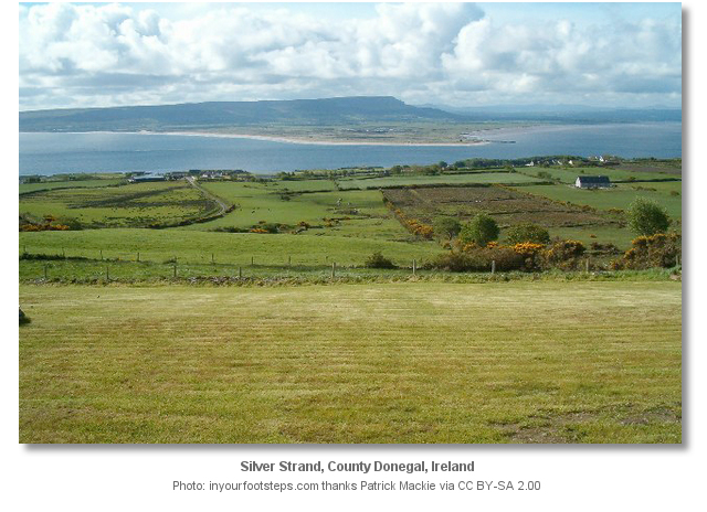
Boats lying at anchorage here will have a view directly across to the Magilligan Penninsula behind which stand the escarpments of Binevenagh, and the irregular curved line of the North Derry Uplands in the background. Indeed the entire north coast as far as Benbane Head, Knocklayd, and inland of Ballycastle on the far horizon, are all visible. Looking to the south, the full sweep of the north Derry Uplands links up with the Sperrin Mountains where Sawel and Dart both appear beyond the lower hills to the east of Loughermore.
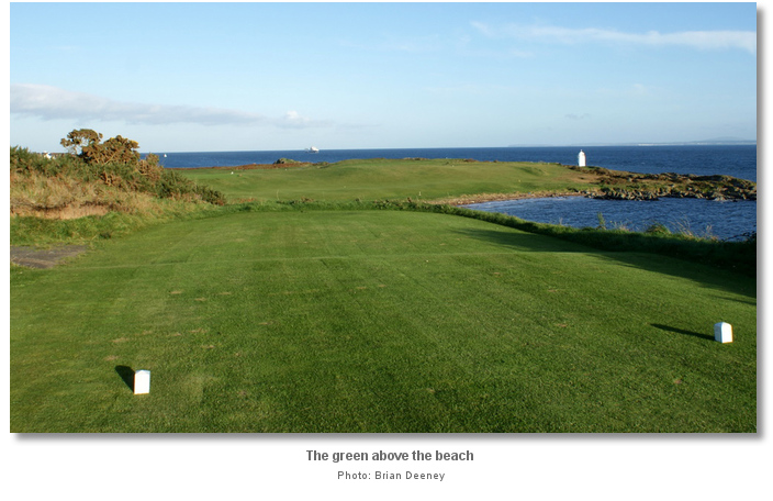
Likewise, those who land will be greeted by the magnificent landscape of eastern Inishowen. The local area is occasionally wooded but is generally bright with wildflowers and hedges; fuchsia, bird's foot trefoil, meadowsweet, tufted vetch and foxgloves. None of this wild flora will be seen immediately ashore as the anchorage is situated on the edge of the perfectly manicured local golf links of one of Ireland's oldest and most idyllic golf courses of Greencastle Golf Club. It was founded in 1892 has been a popular destination for golfers from across the world. Hence golfers who choose to anchor here will have a particular treat at this location.

From a specific boating perspective, Silver Strand makes for an excellent passage anchorage in a beautiful location, or an ideal location to await a favourable tide to enter Lough Foyle.
What facilities are available?
Silver Strand Bay has no facilities and the nearest supplies can be found in the separately covered fishing village of Greencastle or the small town of Moville
  . An alternative is the small village of Stroove a few miles north of the village of Greencastle off the R238.
Any security concerns?
Never an issue known to have occurred to a vessel anchored at Silver Strand.With thanks to:
Bill McCann, Londonderry Harbour Master. Images with thanks to Little Films and Brian Deeney of Donegal Cottage Holidays.
.jpg)

This video presents a video montage of Greencastle Golf Club.
Add your review or comment:
Please log in to leave a review of this haven.
Please note eOceanic makes no guarantee of the validity of this information, we have not visited this haven and do not have first-hand experience to qualify the data. Although the contributors are vetted by peer review as practised authorities, they are in no way, whatsoever, responsible for the accuracy of their contributions. It is essential that you thoroughly check the accuracy and suitability for your vessel of any waypoints offered in any context plus the precision of your GPS. Any data provided on this page is entirely used at your own risk and you must read our legal page if you view data on this site. Free to use sea charts courtesy of Navionics.


