
White Rock Bay is located on the northeast coast of Ireland, within and on the western shore of Strangford Lough directly west of Trasnagh Island. Home to a large sailing club the shallow inlet offers an anchorage on the seaward side of the mooring area and the club also offers visitor moorings and convenient landings.
This is a good anchorage that is particularly well sheltered from westerly winds. However, it is somewhat exposed to strong northeasterly or southeasterly winds where it may be a little uncomfortable. The Lough's enclosed body of water provides sheltered sailing in all weather, all tides and ample marks to make daylight navigation straightforward.

Keyfacts for White Rock Bay


Last modified
November 7th 2022 Summary
A good location with attentive navigation required for access.Facilities


Nature


Considerations
 slyc.co.uk/
Position and approaches

Expand to new tab or fullscreen
Haven position
 54° 29.068' N, 005° 38.231' W
This is in the approach to the bay, immediately outside the mooring area, in about 3 metres.
What are the initial fixes?
The following waypoints will set up a final approach:(i) Dead Man’s Rock Initial Fix
 54° 28.980' N, 005° 36.200' W
This is set on Admiralty Chart 2156's Track Ⓗ a ¼ mile northeast of Dead Man’s Rock.
(ii) Parton Island Initial Fix
54° 28.217' N, 005° 37.763' WThis is situated in the deep water channel between Darragh Island and the Parton Island spit.


What are the key points of the approach?
Offshore details for vessels approaching Strangford Lough from the north are available in northeast Ireland’s Coastal Overview for Malin Head to Strangford Lough  . Details for vessels approaching from the south are available in eastern Ireland’s Coastal Overview for Strangford Lough to Dublin Bay . Details of the approaches, tidal timings, the run up The Narrows and onward to Killyleagh, on the Lough's western shore, are covered in the Entering and exiting Strangford Lough route description.
. Details for vessels approaching from the south are available in eastern Ireland’s Coastal Overview for Strangford Lough to Dublin Bay . Details of the approaches, tidal timings, the run up The Narrows and onward to Killyleagh, on the Lough's western shore, are covered in the Entering and exiting Strangford Lough route description.Not what you need?
Click the 'Next' and 'Previous' buttons to progress through neighbouring havens in a coastal 'clockwise' or 'anti-clockwise' sequence. Below are the ten nearest havens to White Rock Bay for your convenience.
Ten nearest havens by straight line charted distance and bearing:
- Ballydorn and Down Cruising Club - 0.6 nautical miles NW
- Ringhaddy Sound - 2.1 nautical miles S
- Pawle Island - 2.6 nautical miles S
- Kircubbin - 3.4 nautical miles E
- Simmy Island - 3.5 nautical miles S
- East Down Yacht Club - 4.2 nautical miles S
- Don O’Neill Island - 4.5 nautical miles S
- Holm Bay - 4.6 nautical miles S
- Killyleagh - 5.2 nautical miles S
- Between Jackdaw & Chapel Island - 6.1 nautical miles SSE
These havens are ordered by straight line charted distance and bearing, and can be reordered by compass direction or coastal sequence:
- Ballydorn and Down Cruising Club - 0.6 miles NW
- Ringhaddy Sound - 2.1 miles S
- Pawle Island - 2.6 miles S
- Kircubbin - 3.4 miles E
- Simmy Island - 3.5 miles S
- East Down Yacht Club - 4.2 miles S
- Don O’Neill Island - 4.5 miles S
- Holm Bay - 4.6 miles S
- Killyleagh - 5.2 miles S
- Between Jackdaw & Chapel Island - 6.1 miles SSE


What's the story here?
 White Rock Bay
Image: Michael Harpur
The small quiet village of Whiterock set at the head of its shallow inlet is largely known for its Yacht clubs. Principally the Strangford Lough Yacht Club, the largest sailing club in Strangford Lough, with its headquarters and pontoon on the south shore of the bay. But also the, separately listed, Down Cruising Club situated on the opposite side of Sketrick Island which has its base in a converted lightship moored afloat. The small village of Whiterock has a population of about 350 people with good pubs and restaurants. Tucked in behind Trasnagh Island, the bay offers a well-protected anchorage.
 Local boat mooring White Rock Bay
Image: Michael Harpur
There are usually visitor moorings available on the outside of the mooring area, which are yellow buoys marked 'visitors'. Seek advice from the Club Boatman with regard to using these moorings and ferrying details.
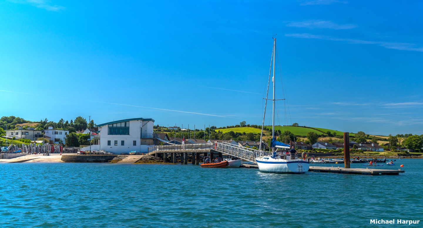
 The clubhouse and pontoon of the Lough Strangford Lough Yacht Club
Image: Michael Harpur
The Strangford Lough Yacht Club pontoon is a single unit used for loading and unloading to service the moored craft within the bay. It may also be possible to come alongside the pontoon jetty for a short stay. 2 metres can be found here ±3 hours of HW. The club may be contacted by
 +44 2897 541883,
  +44 7745 525484,
  office@slyc.co.uk or by a
  web form on their site.
How to get in?
 The approaches to White Rock Bay
Image: Michael Harpur
 Use the approaches, tidal timings, the run up The Narrows and onward to Killyleagh, on the Lough's western shore, as covered in the Entering and exiting Strangford Lough route description. Proceed up the deep water fairway on the Lough’s eastern side using Admiralty Chart 2156's Track E, F and H, to the Dead Man’s Rock Initial Fix. This is located a ¼ mile to the northeast of Dead Man’s Rock which is marked by a perch. Keep the perch on Dead Man’s Rock to port and proceed to the initial fix.
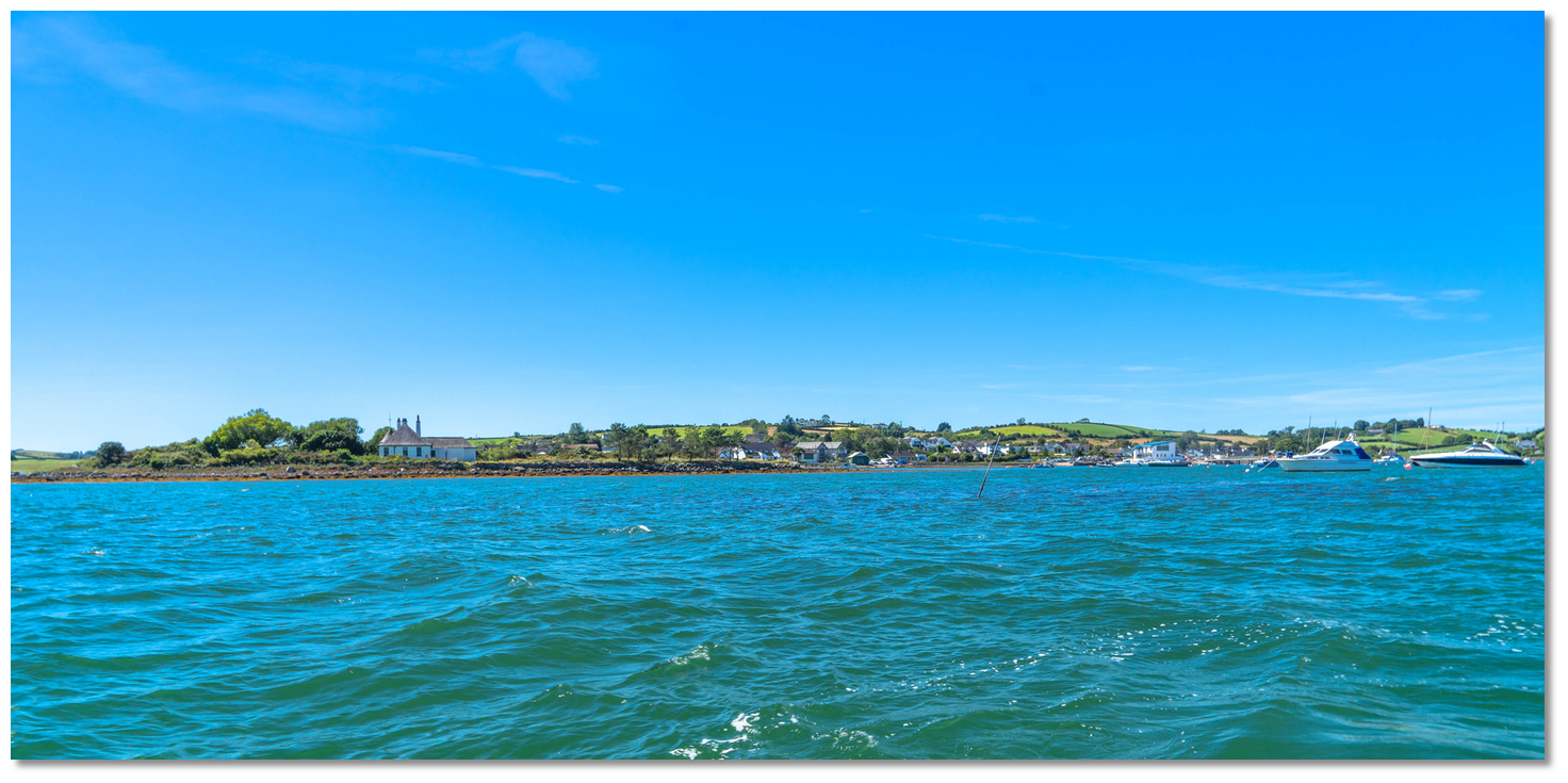
 Trasnagh, Inisharoan and Inishanier islands as seen from White Rock Bay
Image: Michael Harpur
[If] From the Initial Fix the path turns west by northwest for 1 mile passing Inishanier, Inisharoan and Trasnagh Islands to port (southward), until White Rock Bay opens between Sketrick and Trasnagh Islands.
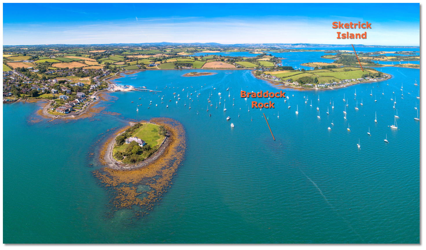
 Braddock Rock situated close offshore off the southern entrance
Image: Michael Harpur
The bay's principal danger is Braddock Rock situated close offshore off the southern entrance of White Rock Bay and almost opposite the southern tip of Sketrick Island. This is marked by a narrow pole which is not easily seen.
 This narrow Braddock Rock pole is not easily seen
Image: Michael Harpur
 Those approaching from Ringhaddy Sound should use the Parton Island Initial Fix located between Darragh Island and the Parton Island spit. The spit extends 400 metres to the northwest of Parton Island with its extremity marked by a pole. It dries halfway out from the island, and a further 200 metres west of the pole there is as little as 1.2 metres of water. Deep draft vessels should favour the Darragh Island side of the channel and particularly so at low water. 2.7 metres can be found 60 metres off of Darragh Island’s northwest point.
 The spit extending from Patron Island
Image: Michael Harpur
Once Darragh and Parton Islands are astern, align a course for the eastern side of Sketrick Island, 345° T and 1 mile north by northwest, pass Conly Island to port and then Braddock Rock marked by a pole.
 White Rock Bay and Braddock Rock as seen from southward
Image: Michael Harpur
When the north end of Trasnagh Island is abeam, or the Braddock Rock marked pole is identified, it is safe to turn to port to enter White Rock Bay.
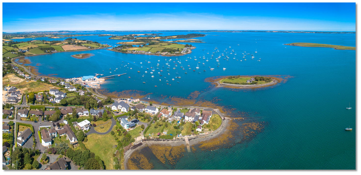 White Rock Bay as seen from southwestward
Image: Michael Harpur
The area to the south of Sketrick Island contains many local vessels on moorings, but there is plenty of room to anchor seaward of these. Holding is not the best over a bottom of light sandy, gravel with some mud but the bay is very sheltered. Land at the slipway alongside the clubhouse.
Why visit here?
It is not known how Whiterock acquired its name but it could have been derived from the white aplite seam in the granite. What stands out today for the first-time visitor, apart from the facilities of the club, are its two legacy features. Sketrick Castle as recorded in 1888
Image: Public Domain
The first is the ruin of Sketrick Castle on Sketrick Island which would once have been the massive fortress. The latter is the minute sheltering Braddock Island which lies close to the shore on the south side of the bay with an impressive period house.
 Sketrick Castle and the causeway as seen from the shore today
Image: Tom Parnell via CC BY 4.0
The castle and island were acquired by Sir Robert Savage in the 14th century. He was the chief of the highly influential Norman Savage family who controlled territories in the Ards, most notably of the castles at Ardkeen and Portaferry, together with a number of the islands off the Ards and Dufferin coasts of the Lough. The 'Annals of the Four Masters', referring to it by the name of 'Sgathdeirge', recorded the Savage family lost the castle and island in 1470 to the nationally powerful O'Neill clan. They moved in to assist their allied clan, the MacQuillans, and after taking the castle left it to them for safekeeping.
 The diminutive Braddock Island
Image: Michael Harpur
But in time it was returned to the Savage family who passed it down through the family to the 16th century when they married into Sir Hugh Montgomery’s family. Since then, it has been passed down from Viscount Montgomery and stayed in the family as indicated in the 'Estate of Hugh Montgomery'. Sadly, it remained largely intact until 1896 when a storm demolished much of it. As late as 1957 a stone subterranean passage was discovered beneath the walls containing a chamber with a freshwater spring. Currently, access to the inside of the castle is not permitted but it can be viewed at any time. The island is also the site of an ancient church, well, graveyard and the famous 'Daft Eddies' restaurant.
 Classic boat moored boat off of Braddock Island
 Image: Michael Harpur
The other feature of the bay is the strikingly pretty Braddock Island with its pretty listed house surrounded by a high wall. The flat oval island is only 100 by 50 metres in size and may be reached by a causeway at low water. It has been owned by the influential Andrews family for over 150 years who have in their line judges and MPs, including prime minister John Andrews, and captains of business. Most notable is Thomas Andrews 1873 – 15 April 1912 who as a boy developed a fascination with boats on Braddock Island.
 Thomas Andrews in 1911
Image: Public Domain
Thomas Andrews was widely known as a warm and kind-hearted man who was modest about his achievements and is widely depicted as such in James Cameron's epic movie Titanic. Accounts of his advice and heroism are plenty after the collision with the iceberg. He was reportedly last seen by a steward approximately 15 minutes before it went down standing alone in the 1st-class smoking room with his arms folded, his lifebelt lying on a nearby table. The Stewart asked him "Aren't you going to have a try for it, Mr Andrews?" Andrews did not answer or move, preferring to stare in a state of shock at a painting over the fireplace that depicted the entrance to Plymouth Sound, which Titanic had been expected to visit on her return voyage. The popular belief is that Andrews accepted his faith, did not attempt to escape and waited for the end in the smoking room which came when the ship split in half.
From a boating perspective, nested within a high drumlin headland and surrounded by a cluster of tiny islands, affectionally known as the 'basket of eggs', this is an anchorage in the heart of an area of outstanding natural beauty. All this and the facilities of the lough’s largest sailing club; Strangford Lough Yacht Club, and the village ashore makes it one of the Lough's most perfect berths.
 The causeway to Braddock Island at low water
Image: Tourism NI
Whiterock and Sketrick Island also provide stunning scenery for tranquil walks. The hidden paths that run around Sketrick Island provide picture-perfect views that everyone can enjoy.
What facilities are available?
Mooring requests, and permission to come alongside the club pontoon, should be directed to the club boatman. A water hose is available at the pontoon jetty. The Clubhouse has a bar and restaurant that typically opens after races on Wednesdays, Thursdays and Saturdays. Daft Eddie's pub and restaurant has a chandlery and sail loft. In Conly Bay, immediately south of White Rock Bay, there is a privately owned boatyard with a slip that can accommodate vessels up to 25 tonnes. Some boat repairs can be catered for here.Whiterock village, with a population of 350 people, has little to offer in terms of provisions. Fresh provisions including vegetables, fruit, butchery, dry goods, gas and petrol are available in Balloo Village 3.5 KM away. Newtownards somewhat further away has a wider selection, including laundry facilities.
Any security concerns?
The Strangford Lough Yacht Club grounds are a secured area within a fenced compound. If you intend to leave your dinghy within the compound it is recommended that you first ascertain as to when the access gates are likely to be locked.With thanks to:
Brian Crawford, local Strangford Lough boatman of many decades. eOceanic would like to thank Quoile Yacht Club for hosting our survey boat during the survey of Strangford Lough.
About White Rock Bay
It is not known how Whiterock acquired its name but it could have been derived from the white aplite seam in the granite. What stands out today for the first-time visitor, apart from the facilities of the club, are its two legacy features.
Sketrick Castle as recorded in 1888Image: Public Domain
The first is the ruin of Sketrick Castle on Sketrick Island which would once have been the massive fortress. The latter is the minute sheltering Braddock Island which lies close to the shore on the south side of the bay with an impressive period house.
Sketrick Castle and the causeway as seen from the shore todayImage: Tom Parnell via CC BY 4.0
The castle and island were acquired by Sir Robert Savage in the 14th century. He was the chief of the highly influential Norman Savage family who controlled territories in the Ards, most notably of the castles at Ardkeen and Portaferry, together with a number of the islands off the Ards and Dufferin coasts of the Lough. The 'Annals of the Four Masters', referring to it by the name of 'Sgathdeirge', recorded the Savage family lost the castle and island in 1470 to the nationally powerful O'Neill clan. They moved in to assist their allied clan, the MacQuillans, and after taking the castle left it to them for safekeeping.
The diminutive Braddock IslandImage: Michael Harpur
But in time it was returned to the Savage family who passed it down through the family to the 16th century when they married into Sir Hugh Montgomery’s family. Since then, it has been passed down from Viscount Montgomery and stayed in the family as indicated in the 'Estate of Hugh Montgomery'. Sadly, it remained largely intact until 1896 when a storm demolished much of it. As late as 1957 a stone subterranean passage was discovered beneath the walls containing a chamber with a freshwater spring. Currently, access to the inside of the castle is not permitted but it can be viewed at any time. The island is also the site of an ancient church, well, graveyard and the famous 'Daft Eddies' restaurant.
Classic boat moored boat off of Braddock Island Image: Michael Harpur
The other feature of the bay is the strikingly pretty Braddock Island with its pretty listed house surrounded by a high wall. The flat oval island is only 100 by 50 metres in size and may be reached by a causeway at low water. It has been owned by the influential Andrews family for over 150 years who have in their line judges and MPs, including prime minister John Andrews, and captains of business. Most notable is Thomas Andrews 1873 – 15 April 1912 who as a boy developed a fascination with boats on Braddock Island.
Thomas Andrews in 1911Image: Public Domain
Thomas Andrews was widely known as a warm and kind-hearted man who was modest about his achievements and is widely depicted as such in James Cameron's epic movie Titanic. Accounts of his advice and heroism are plenty after the collision with the iceberg. He was reportedly last seen by a steward approximately 15 minutes before it went down standing alone in the 1st-class smoking room with his arms folded, his lifebelt lying on a nearby table. The Stewart asked him "Aren't you going to have a try for it, Mr Andrews?" Andrews did not answer or move, preferring to stare in a state of shock at a painting over the fireplace that depicted the entrance to Plymouth Sound, which Titanic had been expected to visit on her return voyage. The popular belief is that Andrews accepted his faith, did not attempt to escape and waited for the end in the smoking room which came when the ship split in half.
From a boating perspective, nested within a high drumlin headland and surrounded by a cluster of tiny islands, affectionally known as the 'basket of eggs', this is an anchorage in the heart of an area of outstanding natural beauty. All this and the facilities of the lough’s largest sailing club; Strangford Lough Yacht Club, and the village ashore makes it one of the Lough's most perfect berths.
The causeway to Braddock Island at low waterImage: Tourism NI
Whiterock and Sketrick Island also provide stunning scenery for tranquil walks. The hidden paths that run around Sketrick Island provide picture-perfect views that everyone can enjoy.
Other options in this area
Click the 'Next' and 'Previous' buttons to progress through neighbouring havens in a coastal 'clockwise' or 'anti-clockwise' sequence. Alternatively here are the ten nearest havens available in picture view:
Coastal clockwise:
Ringhaddy Sound - 1.3 miles SPawle Island - 1.6 miles S
Simmy Island - 2.2 miles S
East Down Yacht Club - 2.6 miles S
Don O’Neill Island - 2.8 miles S
Coastal anti-clockwise:
Ballydorn and Down Cruising Club - 0.4 miles NWKircubbin - 2.1 miles E
Ballyhenry Bay - 3.9 miles SSE
Portaferry - 4.4 miles SSE
Portavogie Harbour - 4.4 miles ESE
Navigational pictures
These additional images feature in the 'How to get in' section of our detailed view for White Rock Bay.


| Detail view | Off |
| Picture view | On |
Add your review or comment:
Please log in to leave a review of this haven.
Please note eOceanic makes no guarantee of the validity of this information, we have not visited this haven and do not have first-hand experience to qualify the data. Although the contributors are vetted by peer review as practised authorities, they are in no way, whatsoever, responsible for the accuracy of their contributions. It is essential that you thoroughly check the accuracy and suitability for your vessel of any waypoints offered in any context plus the precision of your GPS. Any data provided on this page is entirely used at your own risk and you must read our legal page if you view data on this site. Free to use sea charts courtesy of Navionics.