
.jpg)
Macamish Bay is a small isolated inlet on the western shore of Lough Swilly situated about ten miles south of the entrance. The bay affords an anchorage in a beautiful location with the possibility of a dinghy landing on a very attractive beach.
This location offers good shelter in winds between northwest round through west to southeast, and it offers much better protection from the swell than any of the lough's anchorages further north. Straightforward navigation is required for access which is possible at any state of the tide, in all reasonable conditions in daylight, as the bay's central above-water rock has to be identified.

Keyfacts for Macamish Bay


Last modified
July 10th 2021 Summary
A good location with straightforward access.Facilities

Nature


Considerations

Position and approaches

Expand to new tab or fullscreen
Haven position
 55° 8.326' N, 007° 31.415' W
this is the position of the anchorage in Macamish Bay
What is the initial fix?
The following Lough Swilly Initial Fix will set up a final approach:
 55° 17.800' N, 007° 35.030' W


What are the key points of the approach?
Offshore details are available in northwestern Ireland’s coastal overview for Erris Head to Malin Head  . A set of waypoints to assist when running up lough, as far as Fanad, can be found in the Lough Swilly route .
. A set of waypoints to assist when running up lough, as far as Fanad, can be found in the Lough Swilly route .Not what you need?
Click the 'Next' and 'Previous' buttons to progress through neighbouring havens in a coastal 'clockwise' or 'anti-clockwise' sequence. Below are the ten nearest havens to Macamish Bay for your convenience.
Ten nearest havens by straight line charted distance and bearing:
- Buncrana - 2.2 nautical miles ESE
- Scraggy Bay - 2.6 nautical miles NW
- Rathmullan - 2.6 nautical miles S
- Dunree Bay - 3.3 nautical miles N
- The Lough Swilly Marina - 3.5 nautical miles SSE
- Crummie's Bay - 4 nautical miles NNW
- Portsalon - 5.2 nautical miles NW
- Lenan Bay - 6.1 nautical miles N
- Ramelton - 7.3 nautical miles SW
- Pincher Bay - 8.9 nautical miles NNW
These havens are ordered by straight line charted distance and bearing, and can be reordered by compass direction or coastal sequence:
- Buncrana - 2.2 miles ESE
- Scraggy Bay - 2.6 miles NW
- Rathmullan - 2.6 miles S
- Dunree Bay - 3.3 miles N
- The Lough Swilly Marina - 3.5 miles SSE
- Crummie's Bay - 4 miles NNW
- Portsalon - 5.2 miles NW
- Lenan Bay - 6.1 miles N
- Ramelton - 7.3 miles SW
- Pincher Bay - 8.9 miles NNW


What's the story here?
 Yacht anchored close to the central rock in Macamish Bay
 Image: Graham Wilkinson
Macamish Bay is a small isolated inlet located on the Fanad Peninsula in the north of Ireland about 3 miles southeast of Knockalla Point. The bay is entered between Lambs Head and Macamish Point a distance of less than a ½ mile. The anchorage lies in the south part of the bay to the west of Macamish Point, with approximately 3 metres depth.
Macamish Bay is sheltered from the southwest through to north and is subject to much less swell than the lough's anchorages further north. It is exposed to easterly winds and to the swell across the Lough which can make life uncomfortable when moored.
How to get in?
 Macamish Fort with Fanad Head in the backdrop
Image: Tourism Ireland
 Approach details are available in northwestern Ireland’s coastal overview for Erris Head to Malin Head . A useful set of waypoints for the run up lough can be found in the Lough Swilly route .
 The bay is easily identified by the conspicuous Macamish Martello Tower which stands on the north end of Macamish Point. The bay itself is bordered by cliffs, has a rock-strewn shoreline and a central rock that is fairly steep too and always shows.
Deeper draft vessels should note that a ledge with 1.7 metres of cover extends northeastward from the rock. Approach from the northeast either side of this ledge and the helm should expect a strong tidal run across the entrance.
 Land by tender in Macamish beach
Image: Kevin Flanagan
The preferred berth is close west of the Martello Tower, between it and the above-water rock in the centre of the bay, where a depth of 5 metres will be found. Alternatively proceed further in towards the beach and anchor according to draft. Another alternative is to the northwest of the rock.Good sand holding will be found throughout. Land on the beach.
Why visit here?
Macamish Bay is a lovely escape to a shoreline littered with rocky shoals and a clear open sandy beach. The head of the bay is divided by a large rocky outcrop but a dinghy landing on the beach for a picnic or to explore the surroundings is essential.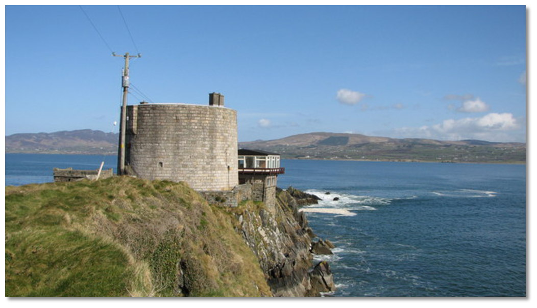 Macamish Fort
Image: Willie Duffin via CC BY-SA 2.0
Set on a rocky outcrop at the head of Macamish Point the Martello Tower was originally entered by a drawbridge. The structure had a single gun on the tower plus a battery covering the lough that mounted three guns. After the conclusion of the Napoleonic Wars, the defences were neglected and completely obsolete when the fort was disarmed in the 1860s. The tower is today a private residence, and the land adjoining the beach is part of the 9 hole Otway Golf Club that is one of Ireland’s five oldest links courses, having been there since 1893.
From a sailing point of view, this is one of the finest anchorages in Lough Swilly. As there are no villages on the coast of Macamish Bay the anchorage is usually a quiet, peaceful and uncrowded location. It is a lovely scenic bay in which to drop anchor for an overnight stay before proceeding onwards to busier harbours around the Lough.
 The view north from Macamish Bay's beach
Image: Kevin Flanagan
What facilities are available?
There are no facilities whatsoever at Macamish Bay and the nearest harbour for re-stocking of provisions is at Rathmullan approximately 2½ miles to the south.With thanks to:
eOceanic.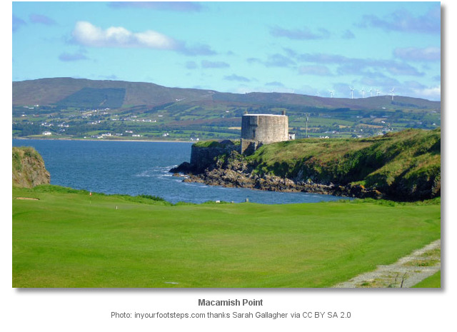
About Macamish Bay
Macamish Bay is a lovely escape to a shoreline littered with rocky shoals and a clear open sandy beach. The head of the bay is divided by a large rocky outcrop but a dinghy landing on the beach for a picnic or to explore the surroundings is essential.
Macamish FortImage: Willie Duffin via CC BY-SA 2.0
Set on a rocky outcrop at the head of Macamish Point the Martello Tower was originally entered by a drawbridge. The structure had a single gun on the tower plus a battery covering the lough that mounted three guns. After the conclusion of the Napoleonic Wars, the defences were neglected and completely obsolete when the fort was disarmed in the 1860s. The tower is today a private residence, and the land adjoining the beach is part of the 9 hole Otway Golf Club that is one of Ireland’s five oldest links courses, having been there since 1893.
From a sailing point of view, this is one of the finest anchorages in Lough Swilly. As there are no villages on the coast of Macamish Bay the anchorage is usually a quiet, peaceful and uncrowded location. It is a lovely scenic bay in which to drop anchor for an overnight stay before proceeding onwards to busier harbours around the Lough.
The view north from Macamish Bay's beachImage: Kevin Flanagan
Other options in this area
Click the 'Next' and 'Previous' buttons to progress through neighbouring havens in a coastal 'clockwise' or 'anti-clockwise' sequence. Alternatively here are the ten nearest havens available in picture view:
Coastal clockwise:
Rathmullan - 1.6 miles SRamelton - 4.5 miles SW
The Lough Swilly Marina - 2.2 miles SSE
Buncrana - 1.3 miles ESE
Dunree Bay - 2 miles N
Coastal anti-clockwise:
Scraggy Bay - 1.6 miles NWPortsalon - 3.2 miles NW
Pincher Bay - 5.5 miles NNW
Mulroy Bay - 6.6 miles WNW
Sheep Haven - 7 miles WNW
Navigational pictures
These additional images feature in the 'How to get in' section of our detailed view for Macamish Bay.


| Detail view | Off |
| Picture view | On |
Add your review or comment:
Please log in to leave a review of this haven.
Please note eOceanic makes no guarantee of the validity of this information, we have not visited this haven and do not have first-hand experience to qualify the data. Although the contributors are vetted by peer review as practised authorities, they are in no way, whatsoever, responsible for the accuracy of their contributions. It is essential that you thoroughly check the accuracy and suitability for your vessel of any waypoints offered in any context plus the precision of your GPS. Any data provided on this page is entirely used at your own risk and you must read our legal page if you view data on this site. Free to use sea charts courtesy of Navionics.