- +Today's Tides for Arklow
- +Arklow's Future Tides
- +Weather for Arklow
- +Advanced Haven Search
- +Contacts and Emergency for Arklow
- +Local Navigation Resources

| High Water | Low Water |
|---|---|
| 21:42 (1.1m) | 04:58 (0.7m) |
| 10:41 (1.1m) | 17:19 (0.6m) |
| Now Rising |  |
| Time to high | 2:03 |
| Total rise | 0.4m |
| Remaining rise | |
| Tide height over CD |
| Mean Spring Curve | Mean Neap Curve | Intervening Period |


(Manual calculation)
(Dover)


Small tidal stream inaccuracies can develop when advancing beyond HW Dover +6. Because of this we only enable today's tidal stream chartlets to advance 24 hours. Future tidal planning is best accomplished by using Arklow's future tides predictor below.
The above image represents the current tidal streams offshore of this haven. Streams attaining three knots and above are highlighted by red arrows
Do you need more information on the tidal graphics?
Arrows represent the direction of tidal streams with lighter or shorter arrows indicating weaker streams. Stronger streams are indicated by heavier or longer arrows, and as mentioned above, red arrows flagging rates of 3 knots and above. Numerals represent [mean neap, mean spring] rates in tenths of a knot. For example the numbers 12,23 would indicate a mean neap of 1.2 knots and a mean spring of 2.3 knots.
More local tidal details
Today's Dublin (North Wall) tides — High waters: 00:52, 13:18, Low waters: 06:35, 18:53Today's Dover tides — High waters: 12:46, 01:00, Low waters: 07:52, 20:05
We are now on Springs.
HW Dublin (North Wall) -0315sp -0200 np, mean level 1.0
MHWS 1.3m MHWN 1.2m MLWN 0.9m MLWS 0.6m
Due to an Irish Sea and Arklow Bank tidal oscillation Arklow has a very small tidal range.
Direction of stream outside the harbour
Dover +0445 North going stream at 1 kn (Dublin +0415)
Dover -0215 South going stream at 1 kn (Dublin -1245)
Close inshore off Arklow, the current has a velocity of about l knot. The offshore currents are stronger and begin later.
Around the banks the north going flood tides tend to the Northwest across the banks and the south going ebb tide tends towards the Southeast. This causes the water to ride up and break on the west of the banks on the flood and on the east on the ebb. Close inshore off Arklow the streams run alongside the coast.
The currents inshore between Cahore Point and Wicklow Head set parallel with the coast. The currents set strongly off Wicklow Head at a velocity of about 4 knots in both directions. The north current off the headland forms a weak counter current between the headland and Wicklow Harbour.

This tool can be used to estimate future costal tidal streams for this area. All that is required are two simple steps:
Step 1: What is the Dover High Water for the target date?
Use a current Dover Tide Table to find Dover High Water for the target date. The National Oceanography Centre offers online tidal predictions for up to 28 days from today. Click here to open their tide table for Dover

Step 2: Input the target date's Dover High Water
Taking a mean tidal offset from Dover's tide, we expect your targetted date's associated local tide at to be:
High waters: Low waters:
Data based on an average tide is only accurate to within one hour, if you more precise times are required use the ISA tidal predictions, with Dublin (North Wall) offset -01:00.
()
| Today's overview |
||||
 |
|
|
|
|
| °C °C |
°C °C |
°C °C |
°C °C |
°C °C |
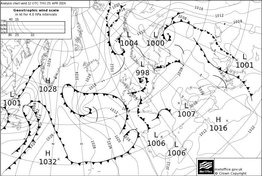
Click [+] to advance by twelve hours and click [-] to step back. The forecasted time is presented in the top left hand corner of the pressure chart. Click the image to display it in a full window.
 Get today's Shipping Forecast for this Sea Area
 Get today's RTE Video Forecast
 Met Éireann Sea Area Forecast
 |  |  |
 |  |  |
| Set your current location | Set the maximum distance you are prepared to travel | Check off what you want |
Dublin Maritime Rescue Co-ordination Centre (MRCC) VHF Ch 83 covers the area from Carlingford Lough to Youghal. Carlingford (04), Wicklow Head (02), Rosslare (23) and Mine Head (83) provide relay stations. Coastguard Radio is always called on a working channel. Emergencies are worked on 16, 67 and working channel.
Alternatively, or if ashore, phone 999 or 112 (free) and ask for ‘Marine Rescue’. Gardai (police), Fire and Rescue are also available on this number. Dublin (MRSC) may be contacted directly on +353 1 662 0922/3
Other useful contacts in this area:
Harbour master – office starboard hand just after the dock entrance.
Radio VHF Channel 16 on entry 12
Sailing Club: VHF Channel 10
Arklow Marina: VHF 16, M1, +353 402 39901/32610
Police: +353 402 32304/5 Doctor: +353 402 32421
British Admiralty 1411 ‘Irish Sea - Western Part’, Scale of 200,000:1 and 1468 Arklow to the Skerries Islands Scale of 100,000:1, British Admiralty 633 ‘Plans on the East Coast of Ireland’ includes a plan of Arklow Scale of 10,000 plus SC5621-13B Arklow. Imray chart C61 St Georges Channel has a plan of Arklow Harbour. Discovery Ordinance Survey maps 56 & 62 cover this area.
Please note eOceanic makes no guarantee of the validity of this information. Whilst every effort has been made to use valid source data and ensure calculations are correct, no warranty is made. All tidal predictions are approximations and differences used to calculate times and heights at secondary ports are based on stated averages that reduce precision. This information is provided as a guide only and is not to be used for navigation. For navigation please refer to published tidal tables. Actual height and time of tides are affected by barometric pressure and other weather effects. Any data provided on this page is entirely used at your own risk and you must read our legal page if you view data on this site.